


【 Double Intelligence Exhibitor Recommendation 】 Central South Architectural Design Institute Co., L
From April 24th to 26th, the 6th Smart City and Intelligent Construction Industry Expo (hereinafter referred to as the "Double Smart Expo") and High-end Forum, hosted by Wuhan Urban Construction Investment and Development Group Co., LTD., will be held at Wuhan International Expo Center. The exhibition will focus on the latest developments and innovative achievements in the smart city and intelligent construction industry, promoting mutual learning and exchange, on-site communication, and common development within the industry, and better serving the high-quality development, efficient governance, and high-quality life of cities.
Since its first establishment in 2019, the Double Intelligence Expo has been successfully held for five sessions. This year's Double Intelligence Expo has been upgraded once again. It is a larger-scale and more influential industry event since its inception. It will present an exhibition area of 60,000 square meters, with over 100 industry leaders gathering together. It is expected that the number of professional visitors will reach 20,000.
Zhongnan Architectural Design & Research Institute Co., Ltd. is a key exhibitor promoted at this year's Double Intelligence Expo.
Enterprise Introduction
Central South Architectural Design & Research Institute Co., Ltd. was established in 1952. It is one of the six earliest regional comprehensive architectural design institutes founded in the People's Republic of China. It has been selected as a "benchmark enterprise" in the management benchmark creation action of key state-owned enterprises by the State-owned Assets Supervision and Administration Commission of the State Council, a typical case of digital transformation of state-owned enterprises by the State-owned Assets Supervision and Administration Commission of the State Council, and a typical case of "Double Hundred Enterprises" by the State-owned Assets Supervision and Administration Commission of the State Council. It has been rated as one of the "Top 60 Engineering Design Enterprises in China" by Engineering News-Record (ENR) of the United States for consecutive years. It was honored with the titles of "Advanced Collective in the National Fight Against COVID-19" and "National Advanced Grassroots Party Organization". Our business scope covers consultation, surveying and mapping, planning, scientific research, environmental impact assessment, surveying, design, review, supervision, project management and engineering general contracting, bidding agency, quality inspection, safety assessment, etc. We provide customers with high-quality and efficient technical and management services throughout the entire process of urban construction and building projects. In recent years, the Central South Institute of Architecture has adhered to the strategic guidance of "three transformations and three upgrades", focusing on "New Urban Construction" as the core and "Digital Economy" and "Dual Connection Economy" as the two base points. It has built a digital construction industry Internet represented by the Engineering Life Cycle Management PLM platform and a digital city industry Internet represented by the urban life cycle management CLM platform. Committed to becoming a digital high-tech company in the field of urban construction in the Web 3.0 era and leading the digital transformation of the industry.
Exhibition Highlights
01 Digital Airport Full Life Cycle Solution
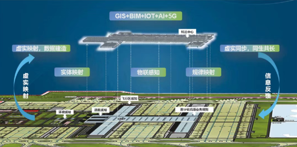
▷ Digital twin foundation and Intelligent hub of the airport
Build a multi-source Internet of Things perception system and create a dual-engine architecture of "digital twin base + intelligent hub". By leveraging digital twin technology, big data, Internet of Things, geographic information and cloud computing and other technologies, a big data system integrating data collection, data governance, data sharing and data display is constructed. Digital twin technology is utilized to achieve two-way interaction between physical and virtual airports. Through real-time business situation awareness and panoramic visualization, Realize the all-domain collaborative operation and guarantee plan simulation, providing a solid data foundation for digital Li Sheng. Achieve the visual display and virtual-real two-way interaction of all elements in the entire domain, and provide complete data support for intelligent operation and maintenance management. Through the all-domain data middle platform, real-time mapping between physical and virtual airports is achieved. Core systems such as AODB, flight management, and resource scheduling are integrated to break down information silos, realize cross-system data governance and intelligent decision-making, and lay the foundation for the digital new infrastructure of smart airports.
▷ Specialized consultation on BIM
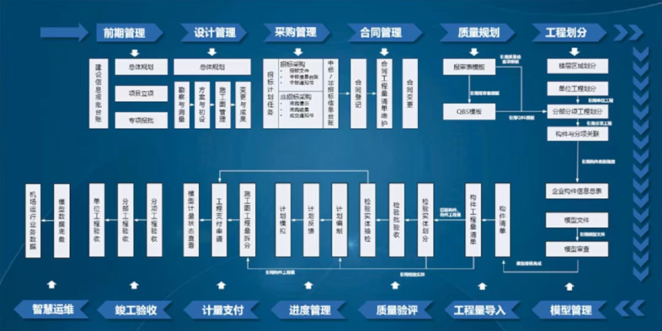
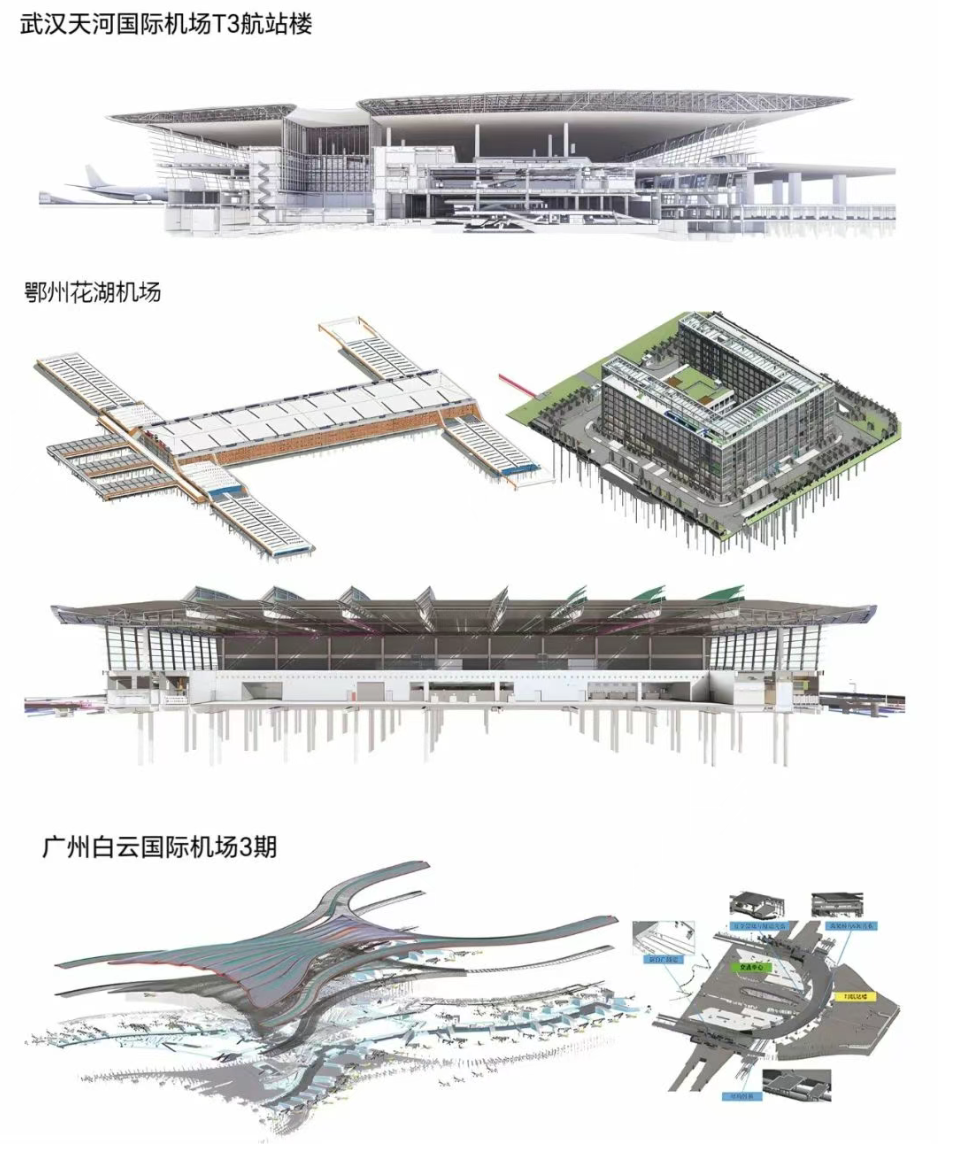
Adhering to the concept of "full life cycle management of construction projects", we provide all-round digital management services centered on BIM models, assist construction parties in implementing management modeling, model review, model application and consulting services, and achieve in-depth application of intelligent construction throughout the entire process, including full coverage, full participation and full participation in the project. The implementation contents include the construction of a unified data environment, the formulation of BIM technical standards, the overall implementation plan of BIM, BIM management details, the compilation of BIM requirements for participating construction parties, the organization and management of BIM meetings, the training of BIM technical capabilities, as well as various BIM application works in the design, construction and delivery stages, and the model review, error detection and tracking of participating construction parties at each stage. The acceptance work of consistency between the graphic model and the physical model.
▷ Full life cycle management platform
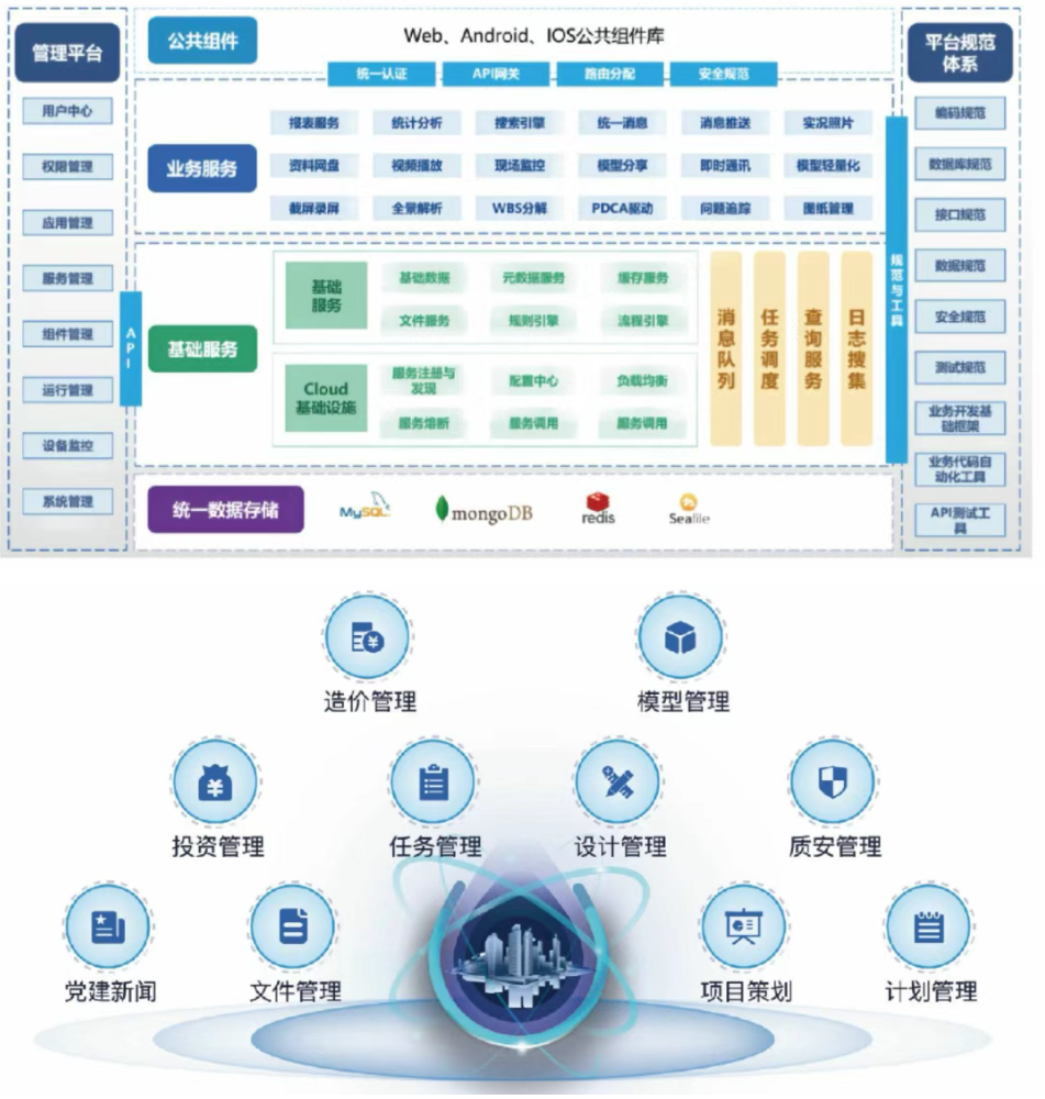
By developing a digital manufacturing platform for the full life cycle management of airports, a smart airport operation platform, and a city management platform for airport economic zones, Zhongguang Digital Intelligence has revolutionized the traditional airport management model, achieving seamless data flow throughout the entire industrial chain, promoting deep integration of the industrial chain, and creating unlimited possibilities for digital and intelligent airports. Independently develop a full life cycle management platform, build a digital airport all-element numerical control database, achieve the integration of maps, models and objects, and realize data collaboration through two ends and one cloud. Promote the integration of the entire model, construction without drawings, intelligent operation, people-oriented approach, sustainable development, and lead the wave of digital, intelligent and low-carbon upgrading and transformation in the civil aviation sector across the country and even the world.
02 Geological Disaster Monitoring, Early Warning and Decision Support Platform
Big data management of all-element geological disasters
The management of all-element geological disaster big data covers the full life cycle management from data collection to integration, distribution, visualization and retrieval, and realizes the systematic management and statistics of multi-source heterogeneous geological disaster-related data such as image data, disaster body data, borehole data and disaster-bearing body data. And it integrates the integrated above-ground and underground real-scene 3D scenes and GIS tools to achieve comprehensive visualization and analysis of spatial data; Meanwhile, by constructing a geological disaster knowledge graph, intelligent question answering and knowledge query are achieved, providing precise decision support.
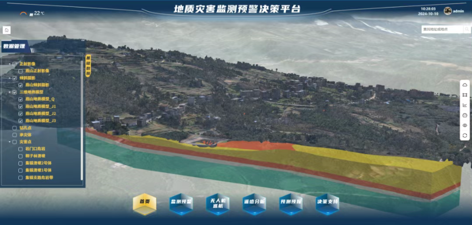
▲ Integrated 3D scene of above-ground and underground
Integrated monitoring and early warning of "air, space and ground"
The platform integrates data from satellite remote sensing (air), unmanned aerial vehicle (UAV) inspection (sky), and ground Internet of Things monitoring equipment (ground), and builds an "air-ground-space" integrated geological disaster monitoring and early warning module. The platform utilizes historical time series SAR satellite image data to achieve high-precision, large-scale and all-weather surface deformation monitoring of geological disaster hazard areas. By carrying various sensors and devices through unmanned aerial vehicles, efficient and automated inspection and monitoring of geological disaster points have been achieved. By leveraging Internet of Things (iot) technology and integrating landslide monitoring equipment, the automatic collection and transmission of monitoring data can be achieved. The platform conducts real-time processing and analysis of the data collected from "air, space and ground", and combines the landslide early warning threshold model to release landslide early warning information, achieving an intuitive display of monitoring and early warning information.
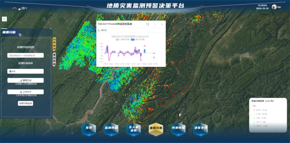
▲ Satellite Remote Sensing (Air)

▲ Drone inspection (Day)
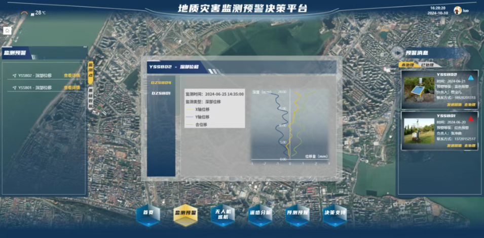
▲ Ground Internet of Things monitoring equipment (ground)
▷ Geological disaster risk assessment based on real-scene 3D
The platform integrates the latest geographic information technology and multiple disaster assessment algorithms, aiming to provide users with accurate disaster risk assessment tools. This module covers regional risk assessment and individual risk assessment, supports multi-scale analysis from the global to the local, provides analysis algorithms such as Runout, conducts landslide movement characteristic analysis through cloud computing technology, and dynamically displays the results to evaluate the possible movement trajectory, velocity variation law, influence range, accumulation body morphology and other characteristics of the landslide. To provide a basis for the risk assessment of landslides, and thereby offer a scientific basis for the prevention and control of geological disasters and emergency decision-making.

▲ Regional risk assessment
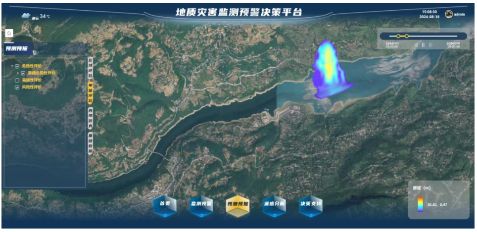
▲ Individual risk assessment
03 Zhongda Engineering Full Life Cycle Management Platform
Zhongda Engineering's Full Life Cycle Management Platform transplanting the product full life cycle management (PLM) concept and model-based Systems Engineering (MBSE) technology from high-end manufacturing to the construction industry breaks the data silos in the traditional construction industry and realizes the three-dimensional collaborative work throughout the entire process and the model of "one model to the end, no drawing construction, and full transparency". The platform's functions cover the entire life cycle of products including digital surveying, digital design, intelligent production, intelligent construction, and intelligent operation and maintenance, fully meeting the requirements of the intelligent construction guidelines. Build a digital twin platform with an industrialized mindset, develop a full life cycle management platform for engineering projects, open up data channels for 3D models, provide integrated solutions for the industry, create a digital "house" in the field of engineering construction, and achieve industrialization, digitalization and greening of digital construction.
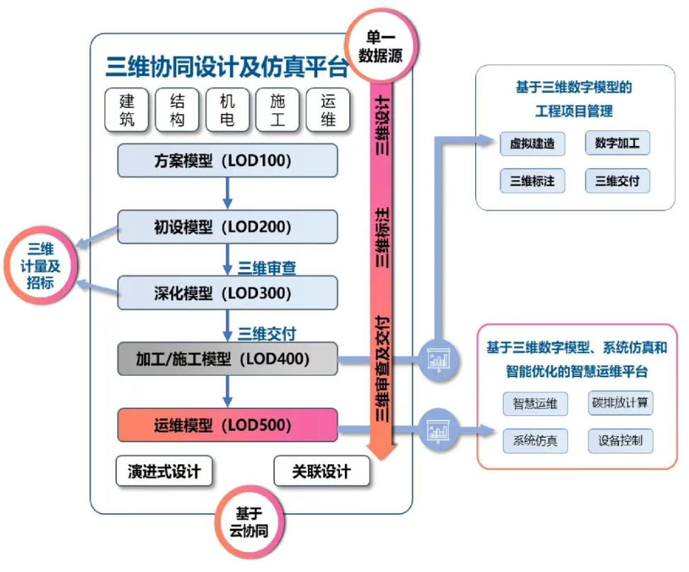
▲ Product function composition of the ZDD platform
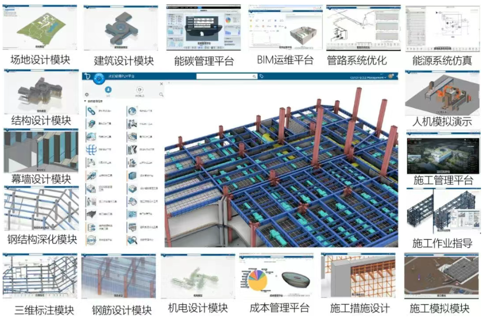
▲ZDPLM platform product matrix
▷ Three-dimensional real-time collaborative design across specialties, enterprises and regions based on the cloud platform
The platform is based on cloud deployment and uses a database to uniformly manage and associate all design data as a single data source, providing project information for users. The problems of inconsistent versions, unassociated data and low user collaboration degree when collaborating through files have been solved. Users carry out evolutionary collaborative design based on the same 3D digital model, that is, while maintaining the correlation of model data, they gradually deepen the model according to the needs of the project stage to jointly form the final twin digital asset.

▲Evolutionary design and relational design based on the same model
Successful practice leads the industry
At present, the PLM platform has been successfully applied in multiple projects such as the Wuhan New Generation Weather Radar Project, the Comprehensive Capacity Enhancement Project of Hubei Provincial Center for Disease Control and Prevention, the Zhongxiang Science and Technology Museum Project, and the Hubei Tobacco Innovation Center, initially achieving the effects of "digital management, precise cost estimation, shortened construction period, and improved quality".

▲ Typical case practice

Scan&Follow

Enter to Program

Service Hotline


